Thunderstorms and high temps raise wildfire risk across the BWCA and Cook County
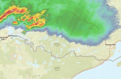
Rain and thunderstorms are on track to move across northeastern Minnesota and the Boundary Waters Canoe Area Wilderness today, including the potential for thunderstorms Monday morning and severe weather this afternoon and evening for Cook County and the BWCA.
In addition to the thunderstorms, temperatures are forecast to be in the 90s again across much of Cook County and the BWCA today, with humidity levels dropping throughout the day. The National Weather Service says a combination of very dry conditions with relative humidity dropping as low as 25 percent and westerly winds gusting up to 20 mph will lead to near-critical fire weather conditions across northeastern Minnesota this afternoon and early evening. In addition, scattered thunderstorms may produce lightning strikes and erratic wind speeds and directions which could further enhance the fire weather threat. Wind speeds of up to 60 mph are possible as thunderstorms move across the region.
Smoke remains thick and the air quality poor across northern Minnesota Monday. Reports from the Gunflint Trail and Grand Marais indicate the smoke today is worse than it has been in recent days. According to the Minnesota Pollution Control Agency, most of the haze and smoke over the region is blowing in from Canadian wildfires. Click here to see a map of wildfires currently burning in Ontario, including Quetico Provincial Park.
The wildfires burning in Quetico north of Ely led to closures in the BWCA over the weekend. Dry conditions persist in the region and the threat for wildfires remains high. To learn more about closures in the BWCA and conditions across Superior National Forest, click here to watch a short video from the U.S. Forest Service that was produced July 18 specific to the current situation and wildfire risk.
WTIP’s Mark Abrahamson spoke with a meteorologist from the National Weather Service in Duluth Monday morning (July 19) to learn more about the potential thunderstorms and wildfire risk. The audio to their conversation is shared below.
Tweet


