


Points North: On the North Shore, Floods Happen
")
Related Stories


| Attachment | Size |
|---|---|
| Finalcut_PN_20120629.mp3 | 5.52 MB |
An Easter Sunday drive last spring included a stop at Jay Cooke State Park south of Duluth. Three of us, Mom, 15-year-old Joe and I, strolled across the famous Swinging Bridge, which spans a boisterous rapids on the St. Louis River. Due to prolonged drought, the river level was well below normal. Mom remarked about the many times she and my late father visited Jay Cooke to see the river’s wild spring flows—when the water was much higher than what we saw last April.
At the base of the bridge was a plaque commemorating the spring of 1950, when the melt water from unusually deep snows raised the river to flood stage and swept away the bridge, which was originally built by Civilian Conservation Corps crews in 1933. Comparing the photos on the plaque to the river that day, it was hard to imagine 1950’s raging spring flood. Little did we know that within three months the river would be even higher.
Last week, Joe called to tell me the Swinging Bridge was washed away in the flooding that occurred near Duluth following unusually heavy rains. He also filled me in on what was happening in his neighborhood, which is near the flood-damaged Duluth Zoo. Tiny creeks and drainages were suddenly raging rivers.
“It’s crazy,” Joe said, “just crazy.”
Certainly, it was the craziest natural event to strike Duluth in Joe’s lifetime, but I couldn’t help thinking back to the city’s last big flood. In 1972, an extraordinary rainfall created a similar disaster, completely tearing out streets along the city’s steep hillside and creating damage at a scale similar to the recent flood. As I recall, that storm or another heavy rain that occurred in the ‘70s washed out bridges along the North Shore’s Highway 61. Some folks still talk about the backcountry detour that was the area’s only link to the outside world until the bridges were repaired.
While the media has made much of Duluth’s disaster, to say such floods are unusual or unprecedented is to ignore not only history, but also current news. In late May, torrential rains struck Thunder Bay, Ontario—on Lake Superior about 200 miles northeast of Duluth--and caused flooding that washed out roads and affected at least 1,100 homes. While the disaster was big news across Canada, it was ignored by Minnesota media. Last year, heavy June rains struck Cook County, where I live, causing road closures and washouts. Again, it was a big event locally, but due to our low population, the rains didn’t leave behind news-making destruction.
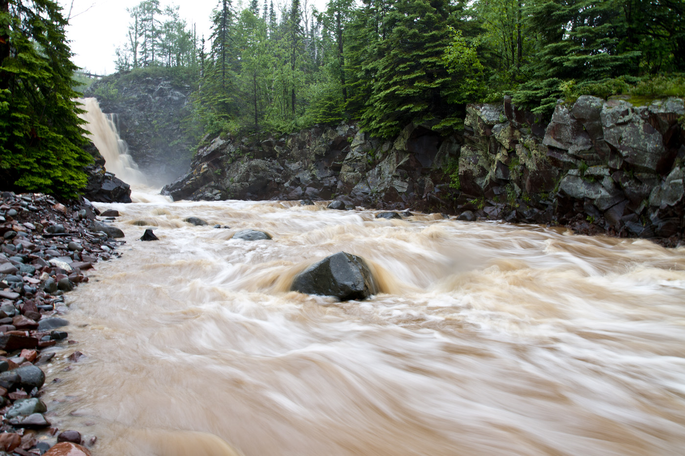
As a lifelong trout fisherman, I’m familiar with the North Shore’s endless cycle of drought and flood. Generally speaking, Lake Superior’s boreal ecosystem depends on lots of moisture from deep winter snow and summer fog and rain. The rugged, rocky landscape has little capacity to retain precipitation, which quickly runs off during the spring melt or after a rain. The water levels in North Shore streams respond quickly to freshets and may rise a foot or more almost immediately after a rain.
Typically, high water has minimal effect on the streams, which essentially flow over bedrock. Exceptions are streams flowing through glacial deposits of sand or gravel, where floodwaters and the debris they contain can scour the channel or cut a new course. I’ve seen this happen on some Ontario streams, such as the Cypress River.
When I first began fishing the Cypress 20-some years ago, it was among the most beautiful trout streams I’ve seen. Flowing over a bed of cobble and gravel, the river meandered through a forest of balsam, spruce and cedar, tumbling over shallow riffles into deep pools. A favorite river of trout anglers seeking steelhead, which make a spring spawning run from Lake Superior, the Cypress was also the last stronghold of Superior’s native “coaster” brook trout.
We used to pack a lunch when fishing the Cypress, because it took the better part of a day to fish through a couple of miles of river. Back then, you could see the river was shaped by occasional floods, because there were places where high flows had cut new channels and piled up log jams of debris. The new channels were essentially long, straight riffles with little cover for trout. We walked around riffles to fish the many meandering pools. Some of the pools were so famous among anglers they’d been given names like Red Rocks, McDougal’s and Scotty’s Run.
The Cypress changed first during the 1990s, when summer rain flooded the river and led to the closure of the Trans Canada Highway. Raging waters roared through the woods on a straight course for Lake Superior. When the flood receded, the meandering stream so loved by anglers was a straight, rocky channel littered with tree trunks and woody debris. The pools at Red Rocks were filled with rocks and scarcely recognizable from before. Fortunately, the upper pools a Scotty’s Run and McDougal’s were intact. However, they were eliminated by another flood a few years later. Steelhead and coasters still spawn in the Cypress, but there are far fewer pools to fish for them. It takes years for a river to dig new pools and clear away debris. For a fisherman’s point of view, the Cypress is slowly recovering, but it will be longer than a human lifetime until it becomes the river it used to be.
We rarely associate flooding with the North Shore, even though it is a regular occurrence. The same can be said of other natural events--wind storms, ice storms, blizzards and wildfire. Acts of Nature have shaped the North Shore landscape for thousands of years. A natural event only becomes a natural disaster when human development is in harm’s way.
Airdate: June 29, 2012
Tweet